Srinagar, Aug 17:
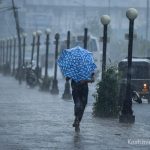
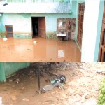
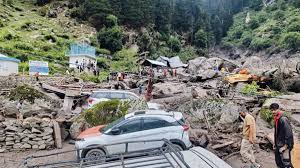
Within just 72 hours, the Jammu division has witnessed two devastating cloudbursts, first in Chasothi village in Kishtwar and now in Kathua district,leaving behind a grim trail of destruction, swollen rivers, and grieving families. The back-to-back disasters, which have claimed dozens of lives, have sparked growing concern: Why is the Jammu division increasingly becoming a hotspot for cloudburst-related disasters?
Experts point to a mix of climate change, fragile geology, aggressive deforestation, and unplanned human activity in the Himalayas.
Research accessed by Rising Kashmir reveals that cloudburst frequency across J&K has spiked in the last two decades, with Jammu division recording more incidents than the Kashmir Valley.
Unlike Kashmir Valley, which is a closed bowl-like basin, Jammu’s topography consists of steep Himalayan slopes, narrow gorges, and deeply incised river valleys. When monsoon winds strike these slopes, moisture-laden clouds often get trapped and release intense rainfall over a very small area.
A 2022 paper in the International Journal of Climatology notes that PirPanjal slopes and the Chenab catchment record extreme rainfall bursts far more often than Kashmir plains, owing to orographic lifting which explains why Kishtwar, Doda, Ramban, Reasi, and Kathua repeatedly face sudden downpours.
Several studies warn that climate change has altered rainfall behaviour in the western Himalayas. Instead of long-duration moderate rains, there is now a rising frequency of short-duration, high-intensity cloudbursts.
A 2020 study in Current Science, accessed by Rising Kashmir found that warming temperatures have injected more moisture into the monsoon system, leading to convective instability.
The paper specifically mentions that the Chenab basin is highly prone to cloudburst-type rainfall due to its geography and changing climate signatures.
“Every additional degree of warming allows the atmosphere to hold 7% more moisture. This is playing out violently in the Himalayas, where localised storms collapse in a matter of minutes,” the paper notes.
Beyond climate, human interference has amplified the disasters. Experts point to indiscriminate deforestation for road construction, power projects, and encroachments on catchments. This has stripped slopes of natural protection, allowing flash floods to gain lethal speed.
A 2019 study in Himalayan Geology, accessed by Rising Kashmir underlined that hydropower tunneling and blasting in Chenab and Ravi valleys has destabilised slopes, reducing their capacity to absorb sudden rainfall. Once heavy rain falls, loose debris and silt rush down in torrents, magnifying the destruction.
An Assistant Professor at IUST while speaking to Rising Kashmir on condition of anonymity said that while cloudbursts are a natural phenomenon, climate change is intensifying their impact and increasing their frequency across the western Himalayas. “We are building roads and dams without slope stabilization, encroaching riverbeds, and blocking natural drainage. Jammu’s fragile slopes simply cannot handle this level of interference,” he said.
He said that disaster preparedness has not kept pace with the scale of risk. Jammu and Kashmir still lacks a robust, village-level early warning system that can alert communities even minutes before a cloudburst. “Had people in Chisoti or Kathua received a 20-minute warning, dozens of lives could have been saved,” the IUST professor added.
He, however, said that there are signs of progress. The Centre of Excellence (CoE) for Glacial Studies has begun installing an Automatic Weather Station (AWS) network in South Kashmir, a step that will help generate real-time data on temperature, humidity, and precipitation.
He added that such data, if integrated with hydrological models, could provide crucial lead time for warnings.
There is also a growing pool of skilled human resources in Jammu & Kashmir, particularly in fields like geospatial analysis, he said adding that there is need to integrate field observations with satellite-based geospatial technologies to develop predictive models and deploy early warning systems across vulnerable catchments like Chenab, PirPanjal, and Kathua foothills.
“Technology and expertise exist, but the challenge is to scale it up, connect it to local administration, and ensure warnings reach the last mile,” he added.
Data from the Indian Meteorological Department shows that these districts record the steepest rainfall gradients in Jammu division. Kishtwar and Doda are carved by the Chenab River and its tributaries, which cut deep gorges with sharp slope angles perfect triggers for cloudbursts.
A 2017 study in Natural Hazards, accessed by Rising Kashmir mapped 60% of J&K’s recorded cloudbursts between 1980–2015 in the Chenab and PirPanjal ranges. Kathua, meanwhile, sits at the Himalayan foothills where monsoon currents pile up, causing sudden cloud collapses.
Experts also highlight micro-climatic zones where converging winds and trapped convection create perfect cloudburst conditions. “You can call these natural cloudburst laboratories,” said the IUST professor.
A 2021 Disaster Management Authority Report, accessed by Rising Kashmir states that unregulated construction in high-risk floodplains is multiplying fatalities. It warns that “Jammu division is on the cusp of an era of recurrent flash flood disasters unless strict zoning regulations are enforced.”
A 2023 paper in Remote Sensing Applications, accessed by Rising Kashmir showed how satellites can detect convective build-up minutes before a cloudburst. But Jammu and Kashmir has no real-time early warning dissemination at the village level.