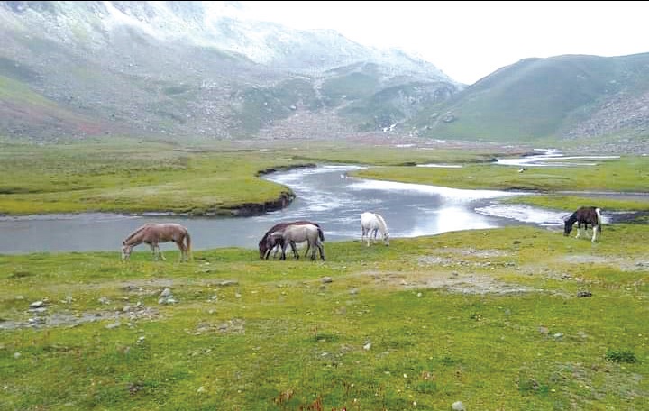
Surrounded by Pir Panjal range of mountains, the heavenly lush green meadow of Gager Rayil falls at the confluence of Shopian and Budgam forest division.
The vast pasture serve as an abode of Shepherd community mostly from Kanidajan village of Budgam who use it for grazing sheep.They stay at this place in huts made of wooden logs and mud from May till beginning week of October.
According to Ghulam Nabi, Ranger Romeshi Forest Range,Gager Rayil falls under Romeshi Range of Shopian Forest Division for management, protection and conservation of its forest resources.
On a sunny day under blue sky, in the backdrop of snow clad Pir Panjal mountains, pristine streams and lush green meadow interspersed with tall pine and fur, this forest enclosed pasture gives a heavenly feel to visitors. A traveler who sojourns here wishes to return again and again.
Such is the attraction of this beautiful place that it has become a routine for many trekkers from Pulwama and adjoining areas to visit it each year during summers. They stay in Dhokis of the shepherd community as guests and some of them trek to upper reaches in Pir Panjal area to explore ancient route to Poonch and Rajouri district of Jammu.
Rising Kashmir learnt from residents of Sangerwani that people in ancient days used Chotti Gali, another pass in Pirpanchal to travel to Poonch and Rajouri. Chotti Gali is situated around 9 Kilometers from Pir Ki Gali in Pir Panjal range along Mughal Road.These days only a few people use this ancient route, they said.
Various streams running down from the Pir Panjal mountains have ice cold water because of their glacial origin and hence taking a dip in them is a daunting and risky job even during perspiring July.
A number of man made interventions add to natural beauty of this place. One such addition is that some shepherds grow green leafy collards here and these vegetable gardens in front of their Dhokis look amazingly beautiful.
The other amusement which strikes visitors is a small water brook at a height which is loading water from a large water stream flowing at a low level. The water loads into the brook against gravitational pull, may be due to capillary action and this water is used by shepherd community at Gager Rayil for drinking, cooking and washing.
However, spending time at this desolate place has its own challenges, one is to arrange food stuff from civil habitations around 6 kilometers down the elevation and other challenge is poor mobile connectivity.
Few yards beyond Gager Rayil, Dhanzaban is another mesmerizing pasture. It is slightly marshy and comparatively larger. Large rocks scattered through these pastures serve as natural matting for visitors to sit on and refresh after a walk.
The shepherds from Kanidajan told that Gager Rayil area used to grow many varieties of wild medicinal herbs including Khot(Picrorhizia) and Pambe Haakh (Rheum). However, due to unscientific extraction of these herbs, these valued medicinal herbs are now found only at higher altitudes in the area.
Bargah is one more meadowy pasture in this area few meters from Gager Rayil which is used for grazing of sheep by shepherd community from Charipora village of Budgam.
Gager Rayil can be accessed by treading three different routes through Shopian, Pulwama and Budgam. It can be reached from Shopian side via Dubjan traversing through Katarkhal, Naidal, Shidak, Thambriyan and Sangam.
From Yusmarg side one can launch the trip starting from Raikoot and traverse through Pathra, Barendab, Churkhal and Sangam.
If one takes Pulwama route, then the trip is to be started from Sangerwani as base and then travel through Anderwali, Barendab, Churkhal, Palnard and Sangam.
Sangam is a small pasture were two streams running down from Pir Panjal mountains confluence as Romeshi. This is good halting site for taking lunch on one bank of the bubbling stream. However, one has to be careful of monkeys found in good numbers at this place.
It takes around 6 hours to reach Gager Rayil from Sangerwani travelling on a steep forest path through boulders, elevations and green pastures.
As the route is to be walked on foot so taking a stick along for support and protection against wild animals is advisable thing.


