Forest fires have become an increasingly alarming issue in Kashmir, particularly during the dry winter months. While the region is known for its pristine forests and snow-capped mountains, prolonged dry spells in winter create snowless peaks and highly combustible conditions, leading to devastating fires that threaten biodiversity, livelihoods, and the environment. Addressing these fires requires deep understanding and public awareness of potential solutions to mitigate future risks.
Unlike summer fires that often result from high temperatures, winter forest fires in Kashmir are primarily driven by dry conditions, human activities, and strong winds. Human negligence, including unattended bonfires, discarded cigarettes, charcoal-making and agricultural burning, significantly contributes to fire outbreaks. Dry winter winds exacerbate the situation, rapidly spreading fires across vast areas, making containment difficult. Additionally, the accumulation of dead leaves, dry pine needles, and underbrush provides ample fuel for fire propagation, further intensifying the risk. Recent California fires are an eye opener to the fact that dry conditions, strong winds and human activities have the potential to trigger an uncontrollable fire causing huge damage to life, property and other resources.
In the past 20 years, there has been an increasing trend in the forest fires reported across Kashmir region during winter primarily due to prolonged dry spells. Even a small spark under such conditions is enough to trigger a massive fire. As per the data accessed from Forest Survey of India for a period of 16 years (2005 to 2021), there have been 154 incidences of forest fire across the districts of Kashmir including Anantnag (12), Baramulla (16), Budgam (7), Kupwara (66), Pulwama (10) and Srinagar (43).
These statistics have hugely increased recently with 998 reports of forest fires across different districts of Kashmir in a relatively smaller period of 4 years (2021 to 2025). Among these Baramulla topped the list with 276 fires followed by Anantnag (205). Other districts that witnessed the significant incidents of forest fire include Pulwama (130), Ganderbal (128), Bandipora (120) and Kupwara (105). Furthermore, the actual forest fires are still higher as per the data of J&K Forest Fires owing to the fact that not necessarily all fires get detected by the remote sensing technology due to limitations of satellite resolution.
The detection of forest fires using satellite data is significantly influenced by the resolution of the sensors. MODIS (Moderate Resolution Imaging Spectroradiometer) owned and operated by NASA, aboard the Terra and Aqua satellites and VIIRS (Visible Infrared Imaging Radiometer Suite) on board SNPP (Suomi National Polar-orbiting Partnership) and operated by the National Oceanic and Atmospheric Administration (NOAA) are the two key sensors used for fire detection, each with different capabilities and limitations. MODIS with a spatial resolution of 1 km allows for global monitoring of large-scale fires, smaller fires or those in fragmented landscapes as in Kashmir may go undetected due to the relatively coarse resolution. SNPP VIIRS, on the other hand, with a spatial resolution of 375 m for active fire detection, has the ability to detect smaller fires.
Healthy forests support agriculture and horticulture by conserving soil, regulating water, and providing habitats for pollinators. Therefore, while addressing the challenges of Kashmir’s agriculture and horticulture-based economy, equal emphasis must be placed on forest health.
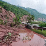
Winter forest fires in Kashmir have severe consequences for both the ecosystem and local communities. The loss of forest cover due to these fires results in the destruction of critical habitats for wildlife, including the endangered Hangul deer, other Himalayan species and other valuable timber and medicinal plants.
Efforts to prevent and manage forest fires require a combination of traditional practices, modern technology, and community involvement. Fire prevention has so far primarily focused on controlled burning to clear dry vegetation, creating firebreaks to prevent fire spread, and planting of fire-resistant species. While there has been a struggle in breakthrough research in the active fire management, yet some reasonable progress has been made in preventive fire technology based on vulnerability and risk mapping.
Real time forest fire monitoring, unmanned aerial vehicles with thermal imaging cameras, automated fire suppression systems (water dropping drones), fire retardant chemicals to create fire breaks and slow the spread of wildfires are some of the technologies used for active fire management. However, preventive measures are highly recommended based on vulnerability assessment and risk mapping. Community-based alert systems and mobile applications provide early warnings and safety instructions to local populations, enhancing preparedness and response capabilities.
J&K Forest department in their efforts to combat forest fires have developed forest fire risk maps in the past besides focussing on active forest fire management tools and logistics. At SKUAST Kashmir’s Division of Natural Resource Management (NRM), Faculty of Forestry, a vulnerability and risk assessment study of Srinagar forests has recently been concluded under a doctoral thesis Program. The study through GIS based modelling approach used vegetation, topographic, climatic and anthropogenic factors to develop forest fire vulnerability/risk maps in urban forest division Srinagar.
With due diligence and capacity of J&K Forest Department, cooperation among the stakeholders and support of the Government, a comprehensive management strategy can be evolved to address this climate change driven threat of forest fires as we can’t afford to be the next Los Angeles as the challenges and associated impact could be far greater than expected.
(Authors can be reached at: [email protected])