Srinagar, Aug 20: Nearly one-eighth of Jammu and Kashmir’s mountainous terrain has been classified as “highly vulnerable” to landslides in a nationwide survey conducted by the Geological Survey of India (GSI). Experts warn that fragile slopes, unplanned construction, and erratic rainfall patterns are exacerbating the risks in the Union Territory.
According to data obtained by Rising Kashmir, the National Landslide Susceptibility Mapping project found that around 3,000 sq km—12% of J&K’s slope areas—fall under the “high” risk category. Meanwhile, 7,000 sq km (23%) are considered “moderate” risk, and nearly 19,000 sq km (65%) fall into the “low” risk category. Ladakh also features prominently, with 21% of its mapped zones designated as high-risk.
Officials said the GSI has completed landslide mapping for the entire Himalayan belt, including Jammu and Kashmir, validating over 33,000 historic landslides. This data has been integrated into the Bhooskhalan mobile app and national map portals, making it accessible to the public.
“This susceptibility mapping is not just academic,” officials noted. “It serves as a crucial planning tool to decide where to build, where to avoid construction, and how to protect vulnerable communities.”
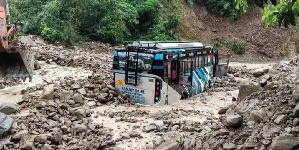
J&K has experienced repeated flash floods and landslides that have cut off key national highways and devastated hill settlements. In 2014, major slope failures in Ramban and Udhampur blocked the Jammu–Srinagar highway for days, while in 2023, landslides near Banihal stranded thousands of travelers.
Building on the baseline mapping, the GSI has completed meso-scale studies at a 1:10,000 scale for 160 critical sectors across India, including stretches of J&K highways, and aims to cover 200 sectors by 2028.
A Regional Landslide Forecasting System is also being developed in collaboration with the India Meteorological Department (IMD) and the Indian Space Research Organisation (ISRO). However, Jammu and Kashmir has not yet been included in the system’s operational districts. Officials indicated that forecasts could be extended to the UT’s most vulnerable areas in Ramban, Doda, and Uri once validated.
For high-risk states and UTs like Jammu and Kashmir, the Centre has pledged special assistance under the National Landslide Risk Mitigation Programme and the AapdaMitra volunteer scheme, which trains local communities for first response during slope failures.