Scattered along the picturesque Kishanganga River, the breath-taking border destinations offer a unique blend of natural beauty, cultural heritage, and historical significance. From the serene valleys of Gurez to the charming villages of Keran and Teetwal, each spot presents a distinct experience—whether it’s adventure, heritage exploration, or simply soaking in the tranquillity of the LoC’s landscapes.
The 245 kilometres long Kishanganga River originates in the Ganderbal district of Jammu and Kashmir near the Krishansar lake and the popular tourist destination, Sonamarg. The river is a captivating watercourse that flows through the various breath-taking valleys of Kashmir. It covers 50 kilometres in the Kashmir valley the remaining 195 kilometres fall in Pakistan occupied Kashmir. From its origin at Sonamarg , the river flows northwards through the Tulail and Gurez Valleys of Kashmir before entering Pakistan Occupied Kashmir. It then continues its course, winding through the Neelum Valley, a lush and picturesque area of Pakistan Occupied Kashmir.
At village Tarabal in Baktoor sector of Gurez valley the river makes its first entry intoPakistan Occupied Kashmir at village Taobat of Neelum District. As it enters Pakistanoccupied Kashmir, the river is called the Neelum as the name of the river was changed to Neelum in 1956 by Pakistan Government after the partition of India in 1947. Kalhanna in Rajatarangini has mentioned the river as Sindhu. M.A Stein is said to have visited the area and have mentioned its name as valley of Kishen Ganga (Ibid 280). At several places of Kupwara district and Bandipora’s Gurez Valley it forms the line of control at several places like Machil, Keran, Teetwal and Bagtoor. The river finally merges with the Jhelum Rivernear the city of Muzaffarabad, capital of Pakistan Occupied Kashmir.
Tributaries and Valleys: The Kishanganga River is fed by numerous tributaries, including the Raman Sind, the Burzil stream, the Machil and the Kel dara, the Kankatori (or Samgan), and the Jagran River of POK. These tributaries contribute to the unique geography and the lush green valleys that the river flows through.
Religious Significance of the Kishanganga River : The Kishanganga River holds immense religious importance for Hindus, particularly the Krishansar Lake and the Sharada Peeth, an ancient temple and learning centre situated near the river in Neelum valley of POK . These sites were visited by Hindu pilgrims during their annual pilgrimage in ancient period. The Sharada Peeth is revered by the Kashmiri Pandit community and is considered one of the most venerated sites for them. Sharada script, the native script for the Kashmiri language, is named in honor of the main deity of Sharada Peeth.
The ancient Sharada Peeth temple, as well as the adjacent ruins of Sharada University are situated in the same Neelam Valley just few miles from Keran . At shardi village where Sharda tample and University is situated the river Kishenganga (Neelum ) joins Madhumati and Sargun streams. Between the 6th and 12th centuries CE, it was among the most prominent temple universities in the Indian subcontinent. Kashmiri Pandit brethren have been demanding opening of the Sharda Peeth corridor for many years now.
Ecological Importance of the River: The Kishanganga River is home to a diverse ecosystem, with various fish species found in abundance in its waters. Some of the most famous fish species found in the river include the Brown trout (Salmo trutta), Rainbow trout (Oncorhynchus mykiss), Snow trout (Schizothorax plagiostomus), Shuddgurn,and Anyour. The river’s proximity to the Line of Control and the uncertainty surrounding the region has resulted in sparse human settlements along its banks, allowing the river’s ecosystem to thrive.
As India and Pakistan continue to invest in hydroelectric projects on the Kishanganga River, it is crucial to strike a balance between development and ecological preservation. The river’s rich biodiversity and its religious and historical significance make it an invaluable resource for both countries. It is essential for India and Pakistan to engage in constructive dialogue and cooperation to ensure the sustainable and equitable utilization of the Kishanganga River and its resources for the benefit of their people and the environment.
Tourist Spots located on the Banks of Kishanganga: I have visited almost all the areas through which the river flows. These include the border areas where this historic river acts as line of control dividing the humans living in Pakistan Occupied Kashmir and in Kashmir valley. These areas were used as an infiltration corridor by the insurgent outfits in past and even now. Thus the Kishanganga river remains under strict observation of the security agencies.
People living along LoC and Kishanganga have been victims of the shells and bombs and the much human blood have flown through the Kishanganga. As on February 25, 2021, India and Pakistan agreed to strictly observe all ceasefire agreements along the LoC and other sectors. With the efforts of Indian Army, the concept of border tourism is a reality now. Lets have a brief introduction of these Kishanganga areas :
Tulail Valley: The Tulail Valley is a captivating region in Kashmir where the Kishanganga River flows through. This valley is characterized by its striking landscape, rich vegetation, and abundant wildlife. It is an area of immense natural beauty, teeming with picturesque vistas and serene spots. Whether you’re looking to unwind in the peaceful surroundings or embark on adventures in the mountains, Tulail Valley offers a perfect escape from the chaos of city life. The simple pleasures of nature and quiet moments of solitude will nourish your soul. The Tulail Valley is sub-valley of Gurez whichlies 120 kilometres northeast of Bandipora and 200 kilometres from Srinagar. Tulail Valley lies immediate east of the Gurez Valley.
Gurez Valley : The Kishanganga River is the lifeblood of Gurez Valley, its turquoise waters meandering through the valley and offering ample opportunities for relaxation and adventure. The river is home to a variety of fish species, making it a popular spot for trout fishing. Visitors can hire local guides to explore the river and its surroundings, and evenindulge in some thrilling white-water rafting experiences.
The Gurez is another mesmerizing area that the Kishanganga River traverses. This valley offers an enchanting blend of unspoiled natural beauty and unique cultural heritage. Gurez is located in the high Himalayas, about 86 kilometres from Bandipore town and 123 kilometres from Srinagar city, in northern Kashmir. At about 8,000 ft above sea level, the valley is surrounded by snow-capped mountains. Razdan Pass connects this valley with Kashmir.
The people of Gurez valley are ethnic Dards (Shins). They have the same styles of dress and culture as their kinsmen in Pakistan held Gilgit-Baltistan. Once part of ancient Dardistan, the valley of Gurez falls along the ancient Silk Route which connected the Kashmir Valley with Gilgit. In village Kanzalwan, the last Council of Buddhism is believed to have been held.
Just a few miles away in Neelum Valley is Sharda Peeth named after the goddess of wisdom Saraswati. It was an ancient centre of learning established in 273 B, even before the Takshila and Nalanda universities. Gurez’s most formidable peak is Habba Khatoon. This pyramid-shaped peak was named after the Kashmiri poet Habba Khatoon. Before the partition of Kashmir, Gurez was a destination for foreign tourists such as Franklin Delano Roosevelt, who is known to have visited the valley some time before he became the US president.
Bagtoor Izmarg: The area is part of Gurez Valley where from Kishenganga river makes its entry into Neelum Valley. Here Kheshanganga cross the LOC and forms the name Neelum. The last village from our side is called as Tarabal and the first village of POK is known as Taobat. Whole Bagtoor areas is as beautiful as rest of the Gurez valley.
Keran: Once part of princely state Jammu and Kashmir, Keran valley got divided into two parts leaving thousands of souls separated from each other. Keran is a beautiful border area with the Kishenganga (Neelum) flowing through it, which acts as line of control between Pakistan Occupied Kashmir and Jammu and Kashmir. On the other side of Kishanganga River is Neelum Valley of Pakistan Administered Kashmir and the village located to the opposite side is also called Keran, 93 kilometres from Muzaffarabad.
Keran is home to many beauties like streams, springs, river, mountains , dense forests including walnut tress and to a variety of Wildlife. 40 kms (approximately) towards west from District headquarter Kupwara Keran wears a majestic view. To reach to the valley one has to Pass through the Firkiyan Gali (Altitude 9634 ft ). On the way to Keran at Firkiyan top the 360 degree view of surroundings is mesmerising and enchanting beauty produces goosebumps. The wooden architecture and style of construction of the house is still standing tall all across the Keran . These precious wooden houses needs to be preserved and protected and need to be promoted as heritage sites. Many woodenhouses existing in Keran have been left behind by their owners whoshifted to the Pakistan during the period of Partition and wars.
Any non-resident traveller, wishing to visit the border areas of Keran, Karnah, and Machil have to obtain permission from District Magistrate Kupwara which is very easy as the interested person need not to visit personally any office but to have to get it through online mode. A non-resident travelcanaccess the portalathttp://epass.kupwara.co.in. and register himself/herself. Along with few governments owned rest houses, there are home stay facilities available for the tourists. Camping tentsare also available along with all basicfacilities.
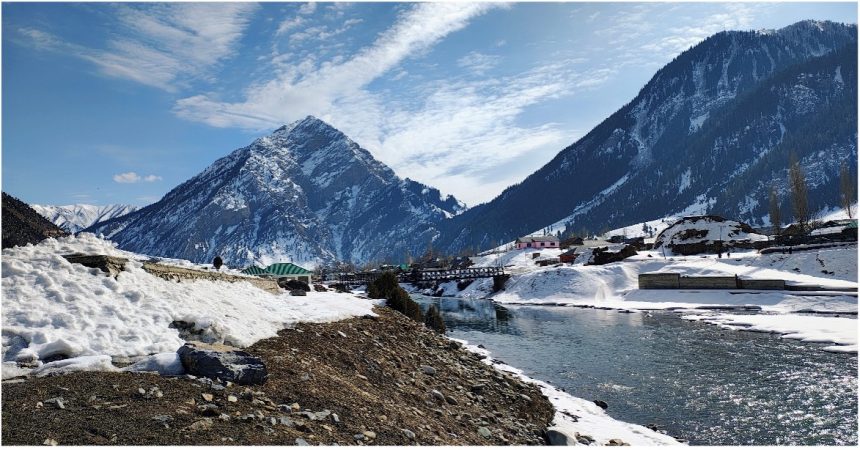
Teetwal and the LOC Bridge: Teetwal, a quaint little hamlet situated on the banks of the Kishanganga river near the Line of Control has a long and rich history. Located in the Kupwara district just at the distance of 14 kilometres from Tangdhar, the area was once a vibrant trade hub along the Silk Road.Traders would rest in Teetwal before crossing the Himalayas, bringing goods from Central Asia and China. In 1846, Teetwal came under the control of the Dogra dynasty. But when India gained independence from Britain in 1947, Teetwal found itself divided between India and Pakistan. This division severely damaged its economy and historical heritage.
At the heart of Teetwal’s divided identity lies the iconic Teetwal crossing bridge. This bridge, originally constructed in 1931 by the British, spans the Kishanganga River. It served as a vital link between the two parts of the village, allowing for the movement of people, goods, and ideas. However, since 2018, the Teetwal crossing bridge has remained closed due to increased tensions between India and Pakistan.
The bridge, once a symbol of connection and unity, now stands as a stark reminder of the physical and emotional barriers that divide families and communities. The white colour line drawn in the middle of the bridge acts as a line of control. This bridge has emerged as the most attractive spot in Teetwal. Armies of both the exchange sweets here on the occasion of festivals.
Additionally, a temple has been rebuilt at Teetwal, which in ancient times was serving as a base camp for pilgrims en route to the Sharda Peeth in POK. The area beyond the LoC bridge in Teetwal is breath-taking, with snow-capped mountains and dense forests but unfortunately the line of control cant allow you to go there.
The Kishanganga River, with its rich history, stunning landscapes, and religious significance, is a fascinating subject of study. The river’s journey showcases the natural beauty and cultural heritage of the Kashmir region. Let us also strive to preserve and protect this valuable gift of nature for future generations. It is essential for both countries to work together to ensure the sustainable and equitable management of the Kishanganga River for the benefit of thepeople and the environment.
(Author is the Content Director of the North Kashmir Gazette, he actively contributes to policy discussions and strategic insights, aligning with the vision of Viksit Bharat. He can be reach on: [email protected])